Sponsored content contributed by AOC Business Partner: EagleView
In today’s fast-paced world, the accuracy and detail of geographic data can be the difference between adequate and exceptional in terms of planning, management, and disaster response. For county governments across Oregon, accessing high-resolution aerial imagery is not just an enhancement but a necessity. Among the most transformative advancements in this area is 1-inch Ground Sample Distance (GSD) aerial imagery, which offers unprecedented clarity and detail.
One-inch GSD imagery represents the distance on the ground each pixel covers, meaning each pixel in a 1-inch GSD image represents a 1-inch square on the ground. This level of detail provides a nearly microscopic view of assets, structures, and features, allowing for more precise assessments and informed decision-making. It transforms the typical guesswork associated with lower resolutions into precise, reliable knowledge of ground conditions.
Enhanced Property Assessment
For property assessors, the detail offered by 1-inch GSD imagery is invaluable. This technology allows for a clearer understanding of property features such as building conditions, land use, and even the type of siding. In Oregon, where diverse landscapes from coastal regions to urban centers present unique challenges, such precise imagery enables more accurate property value assessments and fairer taxation.
Increased Data, Increased Efficiency
With 1-inch GSD imagery, the amount of data and information available is significantly higher than that of lower resolutions. For example, a single pixel of 1-inch GSD imagery contains nine times as much detail as a pixel of 3-inch GSD imagery. This increase in data not only enhances the visual clarity but also reduces the need for frequent site visits. Knowing exactly what’s on the ground through imagery means fewer trips, which increases productivity, saves money, and enhances safety for field personnel.
Improved Planning, Development, and Asset Management
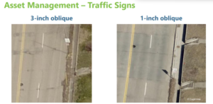
Urban and regional planners benefit greatly from high-resolution aerial imagery. With 1-inch GSD, planners can conduct thorough site analyses without the need for extensive field visits, saving time and resources. This imagery supports the design and implementation of development projects with a high degree of precision, ensuring that every detail is considered—from environmental impacts to zoning compliance. Take this example for asset management. On the left you can tell it’s a speed limit sign but can’t confidently read it. On the right, it clearly reads “Speed Limit 35.” This keeps someone from having to visit the sign to verify asset inventory, and when you’re managing hundreds of thousands of signs, those time, cost, and efficiency savings add up.
Effective Disaster Management
The clarity of 1-inch GSD imagery proves critical in disaster management. Following events like wildfires or floods, it’s crucial for response teams to have detailed visual data to assess damage and strategize recovery efforts effectively. The 2023 Gray fire in Washington showcased how detailed aerial imagery could aid in rapid assessment and help manage the aftermath efficiently, facilitating quicker recovery and minimizing economic impacts.
Encouraging Adoption
Despite its benefits, the adoption of 1-inch GSD imagery among county governments has been varied. Cost and technical requirements can be barriers. However, the return on investment, in terms of enhanced accuracy, time savings, and improved outcomes, often outweighs these initial challenges. As more counties experience and share their success stories, the momentum for embracing this technology continues to grow.
1-inch GSD aerial imagery is not just a tool but a game-changer for county governments in Oregon. It empowers counties to perform better in every facet of their responsibilities, from assessment to emergency response. As we continue to advocate for and invest in these technologies, the scope for their application expands, promising not only to meet but exceed the modern demands of county governance.
Contact Ruth Zipfel, ruth.zipfel@eagleview.com, for a demo to see how 1-inch GSD imagery can transform the way you work.
Contributed by: Megan Reilly, EagleView


