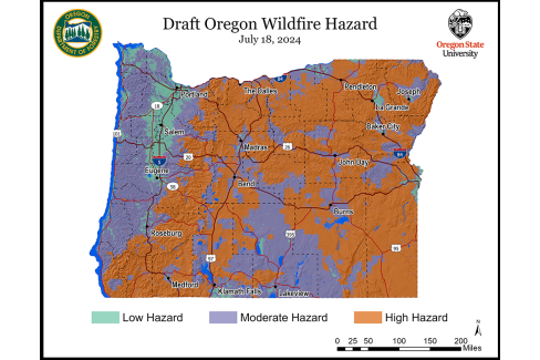
The Oregon Department of Forestry (ODF) released the most recent wildfire hazard map draft on July 18, inviting public review and comment until Aug. 18. Senate Bill 80 (2023) allows counties one additional opportunity to review the map, engage in further discussions, and consider making additional edits if desired. View official draft maps at Wildfire Risk Explorer.
SB 80 Section 1(13)(b) states: county commissioners, upon request by the county commissioners, must have one additional opportunity, arranged and scheduled by the Association of Oregon Counties, with either in-person attendance or a hybrid of in-person and remote attendance, to discuss concerns about the map and potential changes to the map.
County commissioners should notify AOC Staff if they would like to attend this additional opportunity. The meeting will occur in August at the Association of Oregon Counties (AOC) office in Salem. This meeting for counties is separate and distinct from the public comment period. Commissioners are welcome to attend in person or virtually for this discussion. ODF and Oregon State University (OSU) will present the draft map and gather this last round of feedback.
When AOC worked on the wildfire map section of SB 80 with ODF, counties were able to place in statute a series of meetings between counties and the state to ensure local characteristics, which were not factored into the SB 762 version, were considered.
SB 80 states in Section 1 (12): “… to ensure that local characteristics in each area of this state are considered in the mapping process and before the draft map is released, the department shall meet with County Commissioners and the county commissioners’ staff in eight in-person meetings throughout this state.”
Per SB 80 (2023) Section 1(12), in the fall of 2023, AOC hosted eight in-person and one virtual wildfire hazard map meetings in partnership with ODF throughout the state.
ODF and OSU used the gathered information from those meetings to begin implementing the feedback based on the four statutorily permissible criteria: vegetation, topography, weather, and climate. After making changes, ODF and OSU worked with county planning departments around the state to factor in additional local characteristics to the map.
The final version and official publication of the wildfire hazard map is projected to occur in October.
Contributed by: Branden Pursinger | Legislative Affairs Manager

Map courtesy of the Oregon State University College of Forestry and the Oregon Department of Forestry.

