Jul 24, 2024 | Natural Resources
The Oregon Department of Forestry (ODF) released the most recent wildfire hazard map draft on July 18, inviting public review and comment until Aug. 18. Senate Bill 80 (2023) allows counties one additional opportunity to review the map, engage in further discussions, and consider making additional edits if desired. View official draft maps at Wildfire Risk Explorer.
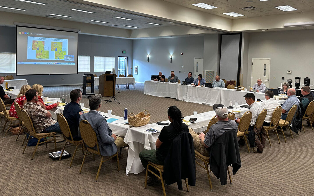
SB 80 Section 1(13)(b) states: county commissioners, upon request by the county commissioners, must have one additional opportunity, arranged and scheduled by the Association of Oregon Counties, with either in-person attendance or a hybrid of in-person and remote attendance, to discuss concerns about the map and potential changes to the map.
County commissioners should notify AOC Staff if they would like to attend this additional opportunity. The meeting will occur in August at the Association of Oregon Counties (AOC) office in Salem. This meeting for counties is separate and distinct from the public comment period. Commissioners are welcome to attend in person or virtually for this discussion. ODF and Oregon State University (OSU) will present the draft map and gather this last round of feedback.
When AOC worked on the wildfire map section of SB 80 with ODF, counties were able to place in statute a series of meetings between counties and the state to ensure local characteristics, which were not factored into the SB 762 version, were considered.
SB 80 states in Section 1 (12): “… to ensure that local characteristics in each area of this state are considered in the mapping process and before the draft map is released, the department shall meet with County Commissioners and the county commissioners’ staff in eight in-person meetings throughout this state.”
Per SB 80 (2023) Section 1(12), in the fall of 2023, AOC hosted eight in-person and one virtual wildfire hazard map meetings in partnership with ODF throughout the state.
ODF and OSU used the gathered information from those meetings to begin implementing the feedback based on the four statutorily permissible criteria: vegetation, topography, weather, and climate. After making changes, ODF and OSU worked with county planning departments around the state to factor in additional local characteristics to the map.
The final version and official publication of the wildfire hazard map is projected to occur in October.
Contributed by: Branden Pursinger | Legislative Affairs Manager
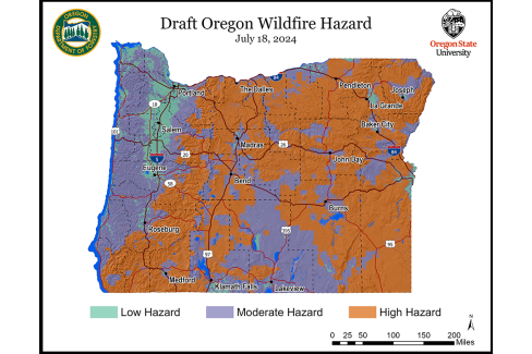
Map courtesy of the Oregon State University College of Forestry and the Oregon Department of Forestry.
Oct 23, 2023 | AOC Advocacy, Natural Resources
Since the state legislative session adjourned in June, the natural resources portfolio at the Association of Oregon Counties (AOC) has been active implementing AOC’s policy priorities passed during the 2023 session and queuing up work for the upcoming 2024 short session.
Senate Bill 80 Regional Wildfire Hazard Map Meetings
Pursuant to Senate Bill 80 (2023), the Oregon Department of Forestry (ODF) and AOC hosted a series of wildfire hazard map meetings throughout the state, beginning the first week of September and concluding Oct. 11.
The State Insurance Commissioner, Building Codes Division Administrator, Oregon State University, ODF, and the State Fire Marshal traveled to nine locations around the state to engage directly with county commissioners, planners, administrators, and emergency managers. During these meetings, counties and ODF discussed the mapping process, hazard identification methodology, and details of the draft hazard maps. ODF will now begin updating the administrative rules to include information collected during those meetings, as well as factoring in the changes made in Senate Bill 80. Counties will be represented on the rules advisory committee, and can continue to raise issues to ensure necessary changes are considered.
Oregon Department of Fish and Wildlife Sage-Grouse Action Plan Update
The Oregon Department of Fish and Wildlife (ODFW) recently began conversations around updating the Oregon Statewide Sage-Grouse Action Plan. The Sage-Grouse Action Plan designates the core and low-density habitats encompassing the populations and assesses the effects these conservation strategies have on the communities where the bird resides. ODFW conducted public outreach around the habitat map updates and have now turned their attention to the “Greater Sage-Grouse Conservation Assessment and Strategy for Oregon: A Plan to Maintain and Enhance Populations and Habitat.”
AOC staff have been asked to serve on this agency strategy plan update. AOC originally produced the appendix in February 2011. AOC has also been asked to update “Appendix VI: Socio-Economic Profile and Analysis of Oregon Counties included in the Greater Sage-Grouse Conservation strategy for Oregon” by the end of this calendar year. AOC staff has begun this work and is gathering information from the eight impacted counties that are within the current range of the greater sage-grouse in Oregon.
Elk Depredation Program
This session, Rep. Bobby Levy (R-Echo) introduced House Bill 3052 (2023) which would have established a task force on elk and deer damage compensation funding. Although that bill did not receive a floor vote, the House Interim Committee on Agriculture, Land Use, Natural Resources, and Water under the chairmanship of Rep. Ken Helm (D-Beaverton and Cedar Hills), created an interim work group to find a path forward on this issue.
The workgroup is made up of 15 individuals and has two primary deliverables. First, they are tasked with producing a short report that documents the workgroup process, discussion, and recommendations on the ideal structure for the program. Second, the workgroup will find an appropriate level and source funding and develop bill language for the upcoming 2024 legislative session.
AOC staff will continue to keep the membership apprised of these activities and developments as the interim continues.
Contributed by: Branden Pursinger, AOC Legislative Affairs Manager
Aug 28, 2023 | AOC News
With the governor’s signing of Senate Bill 80 (2023) in July, the Oregon Department of Forestry (ODF) and Association of Oregon Counties (AOC) began to put in motion a month-long statewide outreach effort to incorporate county input and expertise into a new Wildfire Hazard Map.
AOC successfully advocated for this increased county involvement and representation in the mapping process during the 2023 legislative session and hopes these efforts will result in a well-received and accurate final product.
Pursuant to statute, ODF and AOC will host eight regional Wildfire Hazard Map meetings throughout the state beginning the first week of September, in conjunction with AOC’s eight annual district meetings.
Two weeks prior to their scheduled meeting each region will be provided a draft map for review by county technical staff – planning directors, emergency managers, and administrators.
During the meetings, ODF and state agency representatives will walk through identified areas of concern with county representatives. ODF will provide reasoning for any areas of concern that are unable to be alleviated.
These Wildfire Mapping County Meetings are broken down in the following way.
- AOC District 5: Benton, Lane, and Linn County
- Friday, September 8 in Eugene (Lane County).
- AOC District 7: Clatsop, Columbia, Lincoln, and Tillamook County
- Friday, September 15 in Tillamook (Tillamook County).
- AOC District 4: Coos, Curry, Douglas, Josephine County
- Monday, September 18 in Grants Pass (Josephine County).
- AOC District 2: Crook, Deschutes, Harney, Jefferson, Klamath, and Lake County
- Thursday, September 21 in Klamath Falls (Klamath County).
- AOC District 3: Gilliam, Hood River, Morrow, Sherman, Wasco, and Wheeler County
- Thursday, September 28 in Moro (Sherman County)
- AOC District 1: Baker, Grant, Malheur, Umatilla, Union, and Wallowa County
- Friday, September 29 in Pendleton (Umatilla County)
- AOC District 8: Washington, Multnomah, and Clackamas County
- Wednesday, October 4, in Hillsboro (Washington County)
- AOC District 6: Marion, Polk, and Yamhill County
- Friday, October 6, in Dallas (Polk County)
Governor Kotek has directed all the necessary and appropriate individuals from the executive branch to travel to each regional meeting to participate in person and ensure a thorough and productive process. AOC expects the following state partners to join county commissioners and staff:
Oregon Department of Forestry:
- Cal Mukumoto; State Forester (Availability limited)
- Derrick Wheeler; Legislative Coordinator
- Tim Holschbach; Deputy Chief, Policy and Planning
- Derek Gasperini; Public Affairs Officer
Oregon State University:
- Chris Dunn; Research Associate, Department of Forest Engineering
- Andy McEvoy; Research Assistant
Oregon State Fire Marshal:
- Mariana Riuz-Temple; State Fire Marshal
- Claire McGrew; Fire Protection Risk Administrator
- Chad Hawkins; Fire Protection Risk Manager
Department of Consumer and Business Services:
- Andrew Stolfi, Director and Chief Insurance Officer, DCBS
- Alex Chang; Deputy Administrator DCBS
- Eric Cutler; Section Manager, DCBS
- Alana Cox; Building Codes Division Administrator
- Eric McMullen; Senior Building Code Specialist
Contributed by: Branden Pursinger | Legislative Affairs Manager