Local governments can leverage aerial imagery solutions for a variety of critical roles including:
- Property tax assessment,
- Geographic Information System (GIS) data management and mapping,
- Directing emergency responders,
- Managing and maintaining infrastructure, and
- Helping public safety and emergency management teams plan for, respond to, and recover from disasters.
While most local governments may be using orthogonal (ortho) aerial imagery, not all are using oblique aerial imagery. So, what’s the difference?
Ortho Versus Oblique
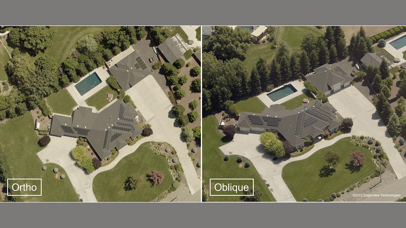
If you’ve ever used Google Earth, you’re familiar with ortho aerial imagery. It’s imagery that is captured at a 90-degree angle, providing a top-down view of the world. Ortho is commonly used in GIS as a “map accurate” background image.
However, because ortho imagery only provides top-down views of structures, landmarks, and other assets, it lacks the perspective needed to determine object height and other features, or to identify details that can only be seen clearly from a side angle (e.g., streetlights, signs, fire hydrants, doors, windows, walls, heating, ventilation, and air conditioning units, garages, etc.). EagleView oblique imagery solves this problem!
EagleView oblique imagery is taken at a 40-to-50-degree angle from low flying aircraft equipped with a camera system that rapidly captures images from all perspectives, offering a clear view from all cardinal directions. These perspectives can then be served together to create a broad-scale, holistic world view. This provides government teams with critical context, allowing them to verify assets in the field (such as signs and traffic lights), and avoid misidentifying structural, situational, and topographical details.
Here are just a few ways EagleView’s high-resolution oblique imagery can be used across multiple departments.
Assessment Boards/County Tax Assessors
The less often assessors must manually inspect properties, the more productive they can be. A key benefit of oblique aerial imagery is the ability to conduct remote property inspections and valuations, making it far easier for assessors to maintain accurate tax rolls, as well as stay on top of property improvements and new construction.
In addition to offering a fast, accurate way to inspect properties, EagleView oblique imagery integrates with leading Computer Aided Mass Appraisal (CAMA) systems, helping streamline workflows and standardize the assessment process.
To get the most benefit for assessments from your aerial imagery portfolio, consider using change detection solutions to compare your latest image capture to historical imagery and data. Accurate change detection helps assessment teams prioritize their remote inspections and desktop reviews. Plus, you can view structural additions or changes from every angle for more accurate valuations.
Disaster Preparedness/Emergency Planning
Oblique aerial imagery supports a variety of emergency management tasks, including:
- Pinpointing areas most vulnerable to flooding, wildfires, and other catastrophic weather events,
- Planning emergency evacuation routes and response staging areas,
- Capturing timely post-disaster imagery for rapid damage assessments, and
- Helping disaster response teams react quickly and confidently.
Advanced tools and image capture techniques can also help teams mitigate and monitor known risk factors. For instance, 3-D mesh visualization tools enable floodplain analysis and water runoff path forecasting. Near-infrared image capture can help teams pinpoint and monitor the condition of vegetation to identify encroachment and wildfire risk.
Geographic Information Systems (GIS)
High-resolution oblique aerial imagery provides GIS teams with the visual context and intelligence needed to maintain accurate and actionable geospatial data, helping the agencies they serve make better deployment and policy decisions.
By providing this level of high-resolution oblique aerial imagery and geospatial intelligence, GIS analysts help the agencies they serve to:
-
- Streamline their workflows,
- Get actionable intelligence,
- Set priorities,
- Make better decisions,
- Efficiently deploy assets,
- Identify geographical context, patterns, and issues, and
- Monitor geographical and structural changes.
Public Works
Oblique aerial imagery provides public works teams with remote access to precise structural details, helping them identify assets and analyze environmental conditions. Teams can locate, inspect, and inventory assets (e.g., fire hydrants, manholes, signage, and traffic signals), measure roads and bridges, and pre-plan infrastructure projects—all without on-site visits.
Oblique aerial imagery can also be accessed using existing software platforms, enabling agencies to easily catalog and monitor their assets, as well as better plan projects and maintain infrastructure.
Public Safety/911
Access to accurate and timely location information is crucial during an emergency. Oblique aerial imagery allows dispatchers, public safety teams, and law enforcement to visualize the scene, saving critical time and providing the intelligence they need to respond safely and effectively.
By integrating oblique aerial imagery with computer-aided dispatch software, dispatchers can quickly pinpoint a 911 caller’s location, share essential site details with emergency response teams, and calculate the fastest possible route.
Law enforcement can conduct remote site reviews when preparing for SWAT raids or service of a warrant, as well as identify surveillance and staging sites.
Fire departments can use oblique imagery for training and for fire response pre-planning—especially to see potential hazards around buildings—as well as current and historic views for fire investigations and reports.
Next Steps
If you’re interested in learning more about the benefits of oblique aerial imagery for local governments or seeing a demonstration of the imagery, please contact Dustin Walters at Dustin.Walters@eagleview.com or 541-325-3781.
Contributed by: Dustin Walters | EagleView
